
Vanadurru Fm
Type Locality and Naming
BASINAL (Local): The type section is in the well Vanadurru South-A (VNS-A) (depth interval: 3370-2623 m). The hypostratotype is in the well Vanadurru-A (depth interval: 2714-2955m). It was named after the Vanadurru village by Raju et al. (2020 in press). [Original Publication: Raju, D.S.N., Reddy, A.N., Shandilya, A., Sagwar, D.P., Kamaraju, A.V.V.S., Thomas, P.D. and Pradeep Durge. (in press) Integrated Mesozoic Stratigraphic Classifications of the Krishna-Godavari Basins of India, In a perspective of Hydrocarbon Exploration – An Overview]
Synonyms: HG-HR unit
Lithology and Thickness
Claystone. It is essentially a black shale sequence with thin sand bodies of transgressive environment. The black coloration is distinct in well cuttings and cores taken spatially. This unit is very diagnostic on well logs represented by high gamma and high resistivity (HG-HR). It has a thickness varying from 241-747m.
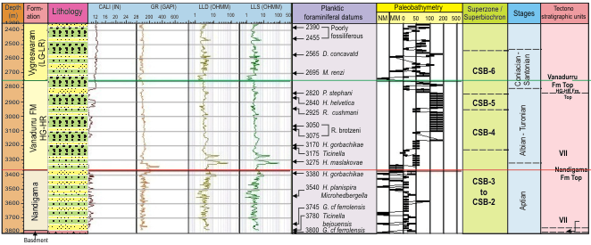
[Figure: Well depth, formation, Gross lithology, electrologs, an indication of Vanadurru Formation, foraminiferal age markers, paleobathymetry trend, Cretaceous super biochrons, standard stages and tectonostratigraphic units details are given for key well VNS-A(ST) (after Well completion report, various ONGC Bulletin, Raju, 2017)]
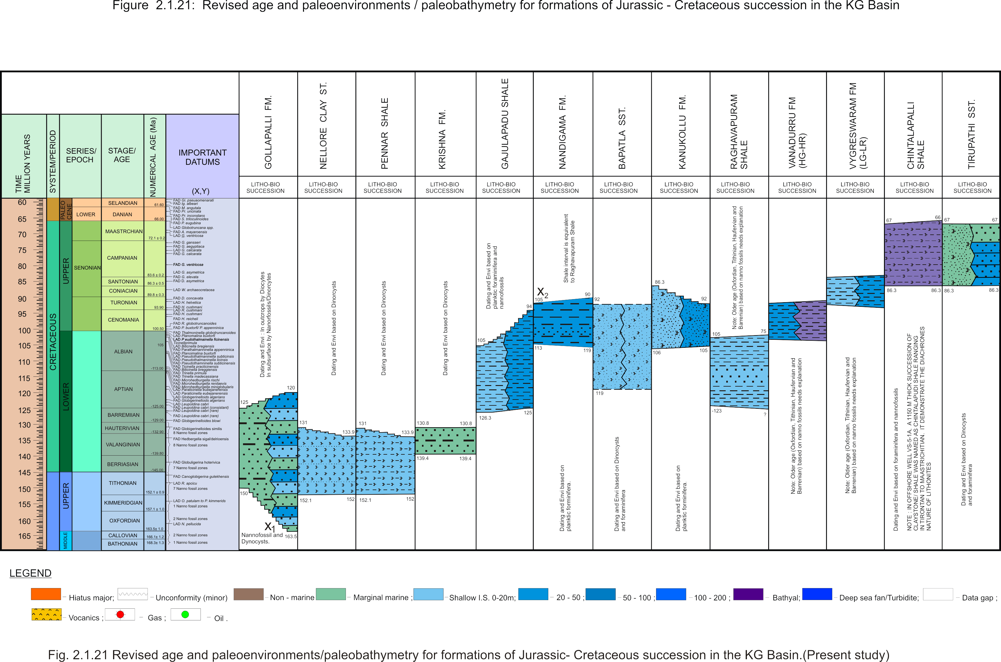
[Figure: A revised stratigraphy chart for the Jurassic and Cretaceous of the KG Basin showing lithological units, their age limits and paleoenvironmental setting (present study) in Raju et al., 2021, ONGC Bulletin, Special Issue, Vol. 56, No. 2]
Relationships and Distribution
Lower contact
Unconformable with the Raghavapuram Fm. The abrupt contact below on electric logs suggests an unconformable relationship.
Upper contact
Unconformable with the Vygreswaram Fm. The abrupt contact above on electric logs suggests an unconformable relationship.
Regional extent
GeoJSON
Fossils
Planktic foraminifer markers include Ticinella raynaudi, T.primula, Rotalipora subticinensis, Rotalipora reicheli, R.cushmani, Helvetoglobotruncana helvetica, H.praehelvetica and Praeglobotruncana stephani.
Age
Depositional setting
Bathyal
[Figure: Revised age and paleoenvironments/paleobathymetry of formations of Jurassic-Cretaceous succession in KG Basin in Raju et al., 2021, ONGC Bulletin, Special Issue, Vol. 56, No. 2]
Additional Information
This unit is distinct on electrical logs characterized by high gamma and high resistivity (HG-HR). The abrupt contact below and above suggests an unconformable relationship with bounding units.